[부캉이 뻘짓 백서] 하와이 타이거 상어 추적 시스템
어느 학문 분야가 그렇듯이 상어를 대하는 한국 수산학 역시 쳐다볼수록 분통만 터져 나오니, 그 출현과 백일간에 걸친 유유자적 부산항 유영, 그리고 그것이 마침내 사라지기까지 일련하는 과정에서 명색이 물고기 연구로 밥 빌어먹고 산다는 자들이 보인 행태가 과연 저놈들이 수산학도 맞는지를 의구하게 되었거니와
그래서 나는 이번 부캉이 사태는 뻘짓 백서로 정리해야 한다고 계속 주장한다.
그 뻘짓 목록을 보면 첫째 오진이다.
처음이 부캉이가 나타났을 적에 뭐라 했는가? 명색 상어학자라는 놈이 나서 하는 말이 가관이었으니 간단히 말해서 치매 걸렸다 했다.
방향을 잃고 방황하니 빨리 외해로 몰아내야 폐사를 막는다는 것이었다.
이 과정에서 보인 희대의 코미디 진단이 부캉이가 맴도는 운하 주변에 전기선이 매설돼 있으니, 전자파에 민감한 부캉이가 그에 영향을 받아 우왕좌왕한다는 논리였다.
둘째, 저런 오진은 결국 부캉이 족대놀이로 발전했다.
족대놀이란 무엇인가? 족대로 물고기를 몰아 잡거나 쫓아내는 방식이라, 비정상적인 행동 양태를 보이는 저 부캉이를 구출하기 위해서라며 멀쩡한 상어를 환자로 몰아 몰아내고자 했으니, 이르기를 그것이 상어를 살리는 길이라 했다.
이것이 뻘짓 아니고 무엇이랴?
셋째, 도대체 출현한지 며칠이 지나서야 상어 종류를 파악했는지 알다가도 모를 일이다. 상어 종류 파악하는데 며칠이나 걸린다고, 내 기억에 이것도 거의 보름이 지나서야 흑상어 운운했을 것이다.
도대체 수산학도들은 뭘했단 말인가?
넷째, 물고기를 연구하는 기본 방법조차 몰랐다는 사실이다. 그래 이렇게 따지면 다 안다 할 것이라는 거 다 안다.
몰라서 못한 게 아니라고 개소리 뻥뻥 칠 것이다.
외국 사례를 굳이 참고할 것도 없이, 행동반경이 어떤지 파악하는 일이 최우선이라, 이를 위해서는 당연히 부캉이한테 추적장치를 달아야 했다.
이런 일이 비일비재하고 한국에서도 철새의 경우 추적장치 달아 추적하는 일은 상례라, 몽골 가서 독수리 잡아 발목 족쇄 채우고, 천수만에 가서 다른 새 잡아 추적한다. 그래서 1년 지나서 저 놈들이 호주까지 날아갔니 하는 연구성과 발표한다.
도대체 이 기본을 망각한 저 놈들 속내를 모르겠다.
상어 어찌 추적하는지 갈켜줘?
난 아래와 같은 사례를 수산학도들이 모를 리 없다고 본다.
등신이 아니고서는 말이다.
물론 할 말은 많을 것이다. 생방송 지켜보는 가운데서 누가 고양이 목에 방울을 달겠는가?
또 상어한테 추적장치 달아본 놈이 있어야지?
그래도 등신은 등신이다.
저리 멍청한 짓을 일삼은 한국수산학은 탄핵해야 한다!
https://www.pacioos.hawaii.edu/projects/sharks/
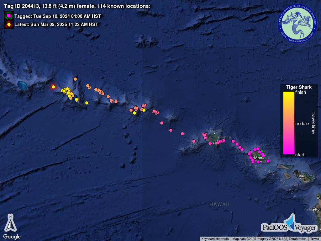
하와이에서 시도하는 호랑이 상어 추적 프로그램이다. 2016년 이래 계속 상어를 추적 중이다.
Projects : Hawaiʻi Tiger Shark Tracking
DISCLAIMER: This is not a warning system and does not provide real-time monitoring.
Tagged Tiger Sharks to Collect Behavioral and Oceanographic Data
2016 – present
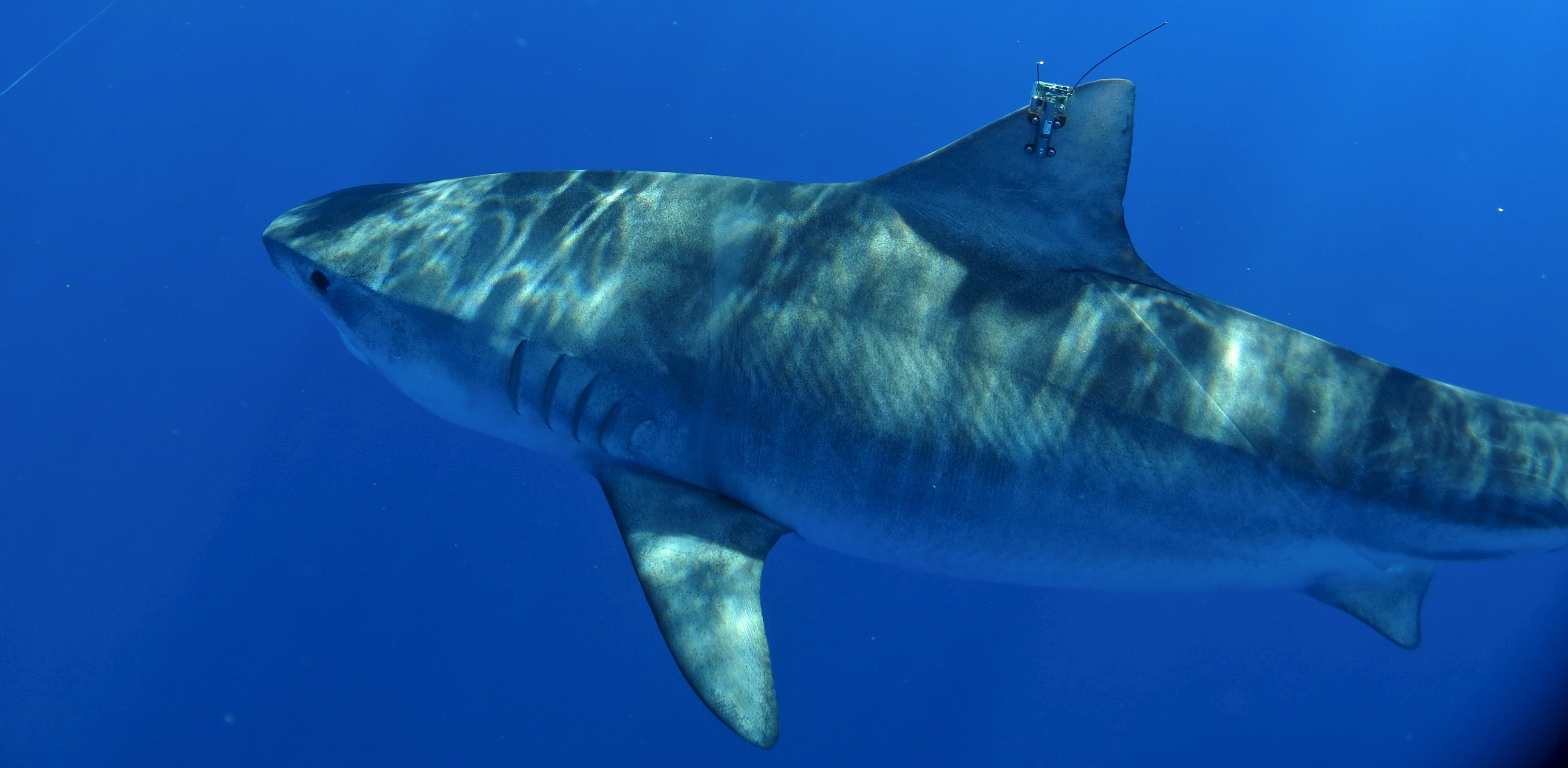
This map shows the movements of Hawaiʻi tiger sharks fitted with the latest generation of satellite tags. These tags are attached to the shark’s dorsal fin and send a signal every time the fin breaks the surface. Pick a shark from the slider to watch tracks from recently tagged sharks. Placing your cursor over a location spot gives you the date and time of the event. The square pink symbol indicates the original tagging location and the bright yellow dot shows the last reported detection. Note that the accuracy of these “fixes” varies from within several yards to up to a mile from the shark’s actual location.
The goal of this project is two-fold. First, the Shark Research Group from the Hawaiʻi Institute of Marine Biology expects to gain valuable insights about shark behavior and habitat selection. Second, the project is testing two new technologies; a new type of satellite tag and a new way of detecting transmissions from those tags.
Tagged Tiger Shark
A tiger shark in the Hawaiian Islands with the latest generation of satellite tags. Photo Credit: Mark Royer.
In addition to the sharks’ locations, this new generation of tags records important oceanographic data, such as ocean temperature and oxygen profiles, and sea surface temperature. The tags are also capable of acquiring GPS–quality positional “fixes” associated with these profiles. Data will be made available in near-real time to databases that inform models to predict ocean circulation patterns (e.g., to improve weather forecasting). This is the first example of using “sharks as oceanographers.”
In the past, data from tagged sharks were solely transmitted through the orbiting satellites system whenever the animal surfaced. However, since Argos satellite availability averages only 6-12 minutes per hour in Hawaiʻi, land-based receivers were installed at high elevations around Maui and Oʻahu to augment the satellite array and increase data throughput from fin-mounted tags. Land-based receivers can significantly increase data recovery and are able to detect signals in a range of 80-90 km. Analysis of performance so far indicates that when a shark surfaces within range of a land-based receiver, 100% of transmitted messages are successfully received.
Temperature profiles will be made available through the Animal Telemetry Network Data Assembly Center.
Project Partners
Data are collected by Principal Investigators Kim Holland, Ph.D. and Carl Meyer, Ph.D. along with other members of the Shark Research Team of the Hawaiʻi Institute of Marine Biology (HIMB) of the School of Ocean and Earth Science and Technology (SOEST) at the University of Hawaiʻi at Mānoa (UH). PacIOOS provides ongoing support for the Shark Research Team and the U.S. Integrated Ocean Observing System (IOOS) is currently supporting efforts as part of the Ocean Technology Transition (OTT) Project.
University of Hawaii at Manoa logo SOEST logo HIMB logo IOOS logo PacIOOS logo
Distribution Maps at a Glance
Below are the latest maps for each shark track. Click on a thumbnail for a larger image.