<Location of Excavation>
카카오맵
당신을 좋은 곳으로 안내 할 지도
map.kakao.com
Evidence for the Construction and Extension Methods of Pungnap Earthen Fortification(Pungnaptoseong)
The Ganghwa National Research Institute of Cultural Heritage (GNRICH, Director YU Jae-eun), under the Cultural Heritage Administration (CHA), will disclose the results of the evidence found for the construction and extension methods of Pungnaptoseong(also known as the Earthen Fortificationin Pungnap-dong or Pungnap Earthen Rampart, Historic Site No. 11) through the official YouTube channel of the Cultural Heritage Administration on Tuesday, December 1 at 2 p.m.
* Excavation site of Pungnaptoseong: 310 Pungnap-dong, Songpa-gu, Seoul
* The official YouTube channel of the Cultural Heritage Administration : https://www.youtube.com/chluvu

The Ganghwa National Research Institute of Cultural Heritage has conducted excavation of the west rampart of Pungnaptoseong since 2017. At the time, only a section of the south west wall was revealed on the surface, and only a trace of the foundation was identified through a survey of the scheduled construction site of the new Sampyo Headquarter Building, which was conducted by the National Research Institute of Cultural Heritage (NRICH) from 2002 to 2003.
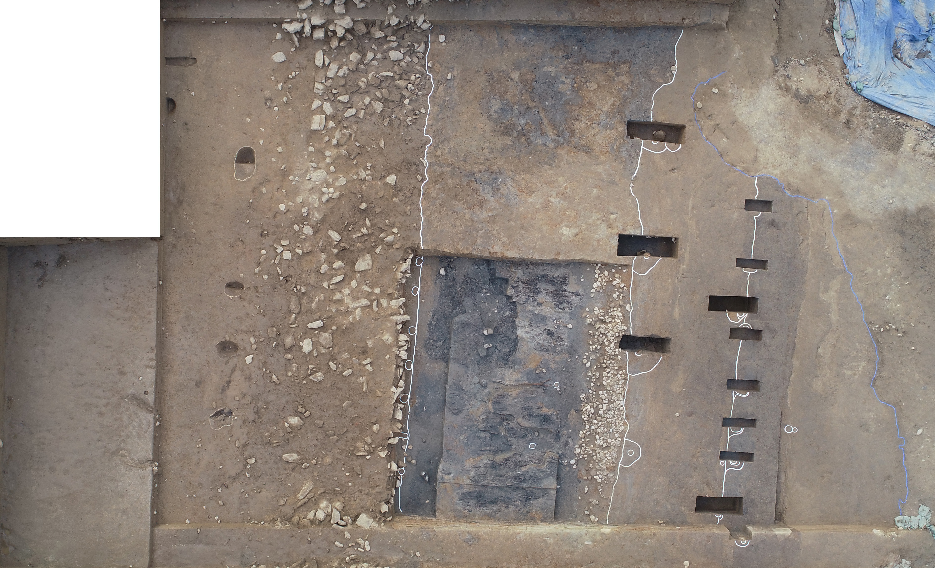
The excavation survey conducted from 2017 confirmed the direction, scale, and structure of the west rampart along with the site of the west gate.
Horizontal excavation was undertaken in this area for the first time to check how the west ramparts were constructed.

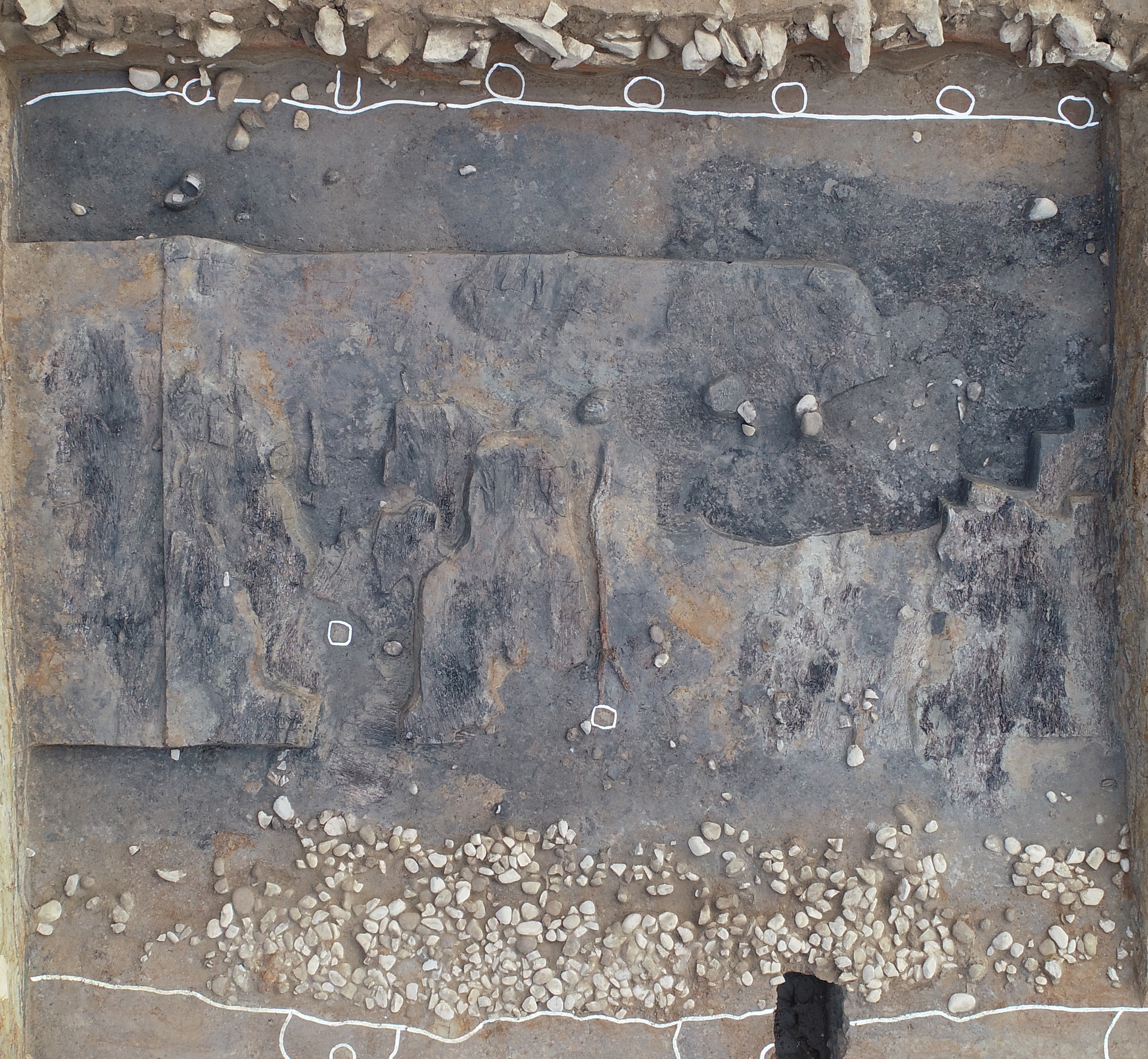
As a result, wooden posts were discovered in soil layers or toru, which was installed to build the walls of the Rampart.
It is estimated that the wooden posts were mounted and soil was stacked from the bottom of the toru or heap of soil. Currently, within a single toru*, layers of soil were stacked with wooden columns installed at intervals of 88 to 162cm. A total of six wooden posts were identified.
Wooden posts were discovered in single, double and triple toru as well, which was used to stack the walls of the earthen rampart.
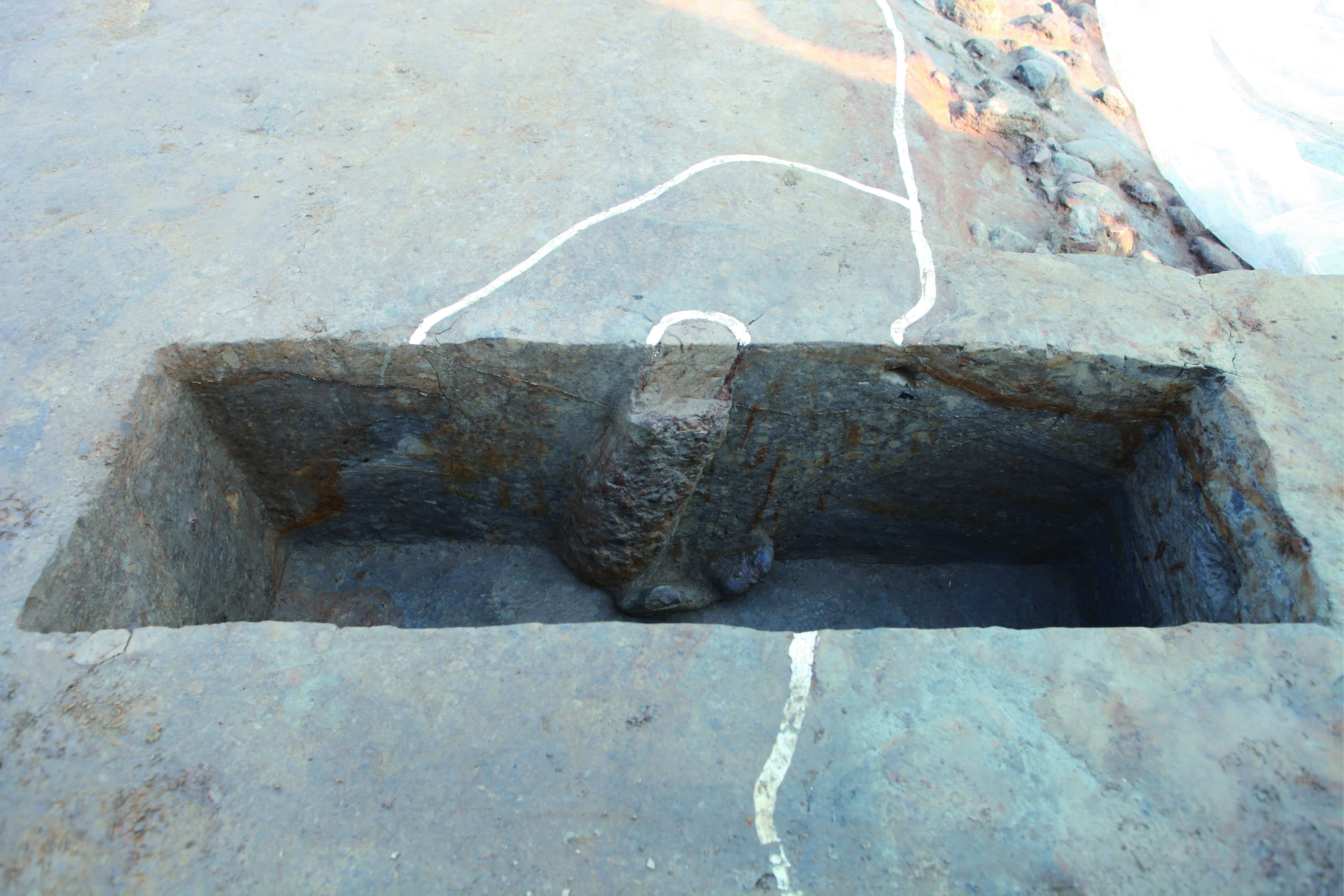
In particular, stones are are installed at the boundary between the double and triple toru to support the wooden posts located in the direction and in the opposite direction of the ramparts.

The wooden posts in the opposite direction of the ramparts were first identified in the Pungnaptoseong and are presumed to be part of the construction method or the structure of the fortress wall.
The wooden posts identified in the west rampart of the Pungnaptoseong are an important clue to the construction method and process of the rampart.
This provided important clues to the construction method and process of the rampart.
* Toru: A pile of earth that forms thebodyofPungnaptoseong. Pungnaptoseongwasbuiltbystackinga single toru, which is the central frame and mounds of soil were added several times (doubletoru, triple toru).
In building the walls, the panchuk or stamped earth method was used where layers of stamped earth was filled in the wooden frames and seongto or mound layering technique of stacking different soil in alternation were used at the same time.

Also, clear evidence of the expansion of the rampart wall was found after the original construction.
Evidence of this is the appearance of buseok facility, which was found between the original construction layer (single and double toru) and the expansion layer (triple toru).
After the construction of single and double toru, a buseok facility is laid to reinforce the inner wall of the rampart, which was used for a certain period of time.
Subsequently, triple toru is mounded on top of the buseok facility for extension. The traces of this extension was clearly identified during this excavation.
* Buseok facility: One or two thin layers of stone on the floor or periphery

Pungnap Earthen Rampart is a large-scale earthen fortification with a width of 40 to 50 meters, height of 11 meters and a circumference of 3.5 kilometers or more, which is believed to have been expanded several times.
The hypothesis on the expansion of Pungnap Earthen Rampart has been continuously discussed since the excavation in 2011, but there were various interpretation up to now.
Based on the buseok facility (inner wall reinforcement) identified in this excavation, the boundary between the original and the expansion layers of the wall was clearly identified.
This investigation is meaningful in that the discovery of wooden posts used in the construction of Pungnap Earthen Rampart confirmed its controversial construction method.

In addition, solid evidence of extension of walls is expected to be used as an important resource for future research on the construction method of Pungnaptoseong.
Based on the results of this year's excavations, the Cultural Heritage Administration's Ganghwa National Research Institute of Cultural Heritage will continue to conduct thorough research and investigation in 2021 on the construction method of Pungnap Earthen Rampart, and take the lead in uncovering the realities of the Pungnaptoseong of the Baekje Kingdom.
풍납토성 축조 방법과 증축 단서 확인
- 국립강화문화재연구소, 온라인으로 조사 성과 공개 12.1. 오후 2시 -
문화재청 국립강화문화재연구소(소장 유재은)는 사적 제11호인 풍납토성의 축조 방법과 증축의 단서를 확인하고 그 성과를 오는 12월 1일 오후 2시에 문화재청 유튜브 채널에서 공개한다.
* 풍납토성 발굴조사 현장: 서울특별시 송파구 풍납동 310번지 일대
* 문화재청 유튜브: https://www.youtube.com/chluvu
국립강화문화재연구소는 2017년부터 풍납토성 서성벽 구역에 대한 발굴조사를 진행해 왔다. 당시 서남벽의 일부 구간만이 지표상에 드러나 있었고, 2002년부터 2003년까지 국립문화재연구소가 실시했던 ㈜삼표사옥 신축예정부지 조사를 통해 기초 흔적 정도만 확인되었던 곳이다. 2017년부터 실시한 발굴조사로 서성벽의 진행방향, 규모, 구조와 함께 서문지가 확인된 바 있다.
이번 조사는 서성벽의 축조 방법을 확인하기 위해 처음으로 시행한 평면조사로, 그 결과 토루별로 성벽을 쌓아 올리기 위해 시설한 나무기둥을 발견할 수 있었다. 나무기둥을 토루 하단부터 켜켜이 박아 흙을 쌓아 올린 것으로 추정된다. 현재 1토루 내에서는 성토를 위한 나무기둥을 88~162cm 간격으로 박아 시설하였으며 나무기둥은 총 6단이 확인된다. 1토루뿐만 아니라 2토루와 3토루 내에서도 토성을 쌓아 올리기 위한 나무기둥이 시설되었다.
특히, 2토루와 3토루 경계에는 성벽 경사방향과 상이한 역경사 방향의 나무기둥과 기둥을 받치기 위한 석재가 시설되어 주목된다. 역경사의 나무기둥은 풍납토성 성벽에서 처음 확인된 것으로 성벽을 쌓아 올리기 위한 공법 혹은, 성벽 시설물의 일종으로 추정된다. 풍납토성 서성벽에서 확인된 나무기둥은 성벽 축조 방법과 공정을 파악할 수 있는 중요한 단서라고 할 수 있다.
* 토루(土壘): 풍납토성 몸체를 이루는 흙더미. 풍납토성은 중심골조에 해당하는 1토루를 쌓아올린 후 수차례 토루를 덧대어(2토루・3토루) 쌓아올리는 방식으로 축조함. 성벽을 쌓아 올릴 때 흙을 켜켜이 다져 쌓아 올리는 판축(版築)기법과, 서로 다른 흙을 교차로 쌓아올리는 성토(盛土)기법도 동시에 나타남.
또한, 처음 성벽을 축조한 이후 증축한 명확한 증거가 발견되었다. 초축면(1ㆍ2토루)과 증축면(3토루) 사이에서 발견된 부석시설이 그 증거다. 초축면인 1ㆍ2토루 축조 이후 성 안쪽 벽을 보강하기 위한 부석시설을 하고 성벽을 일정기간 사용한다. 이후 증축을 위해 3토루를 부석시설 위로 쌓아 올렸던 흔적이 토층에서 고스란히 확인되었다.
* 부석(敷石)시설: 바닥이나 둘레에 한두 겹 얇게 깐 돌.
풍납토성은 폭 40~50m, 높이 11m, 둘레 4km 이상의 대규모 토성으로 몇 차례의 증축이 있었던 것으로 판단된다. 풍납토성 증축에 대한 가설은 지난 2011년 발굴조사 이후 지속적으로 논의되어 왔으나 현재까지 증축공법에 대한 해석이 분분한 상태였다. 이번 발굴조사에서 확인된 부석시설과 이후 쌓아 올린 3토루를 근거로 초축면과 증축면의 경계를 명확히 밝혀낼 수 있었다.
이번 조사는 풍납토성 축조에 사용된 나무기둥의 발견으로 그동안 논란이 되어 왔던 풍납토성의 축조방식을 확인할 수 있었다는데 의의가 있다. 또한 증축의 확실한 근거를 밝혀 풍납토성 축조방식 연구에 중요한 자료로 활용될 것으로 기대된다.
문화재청 국립강화문화재연구소는 올해 조사성과를 토대로 2021년에 정밀조사를 하여 풍납토성의 축조방식에 대한 더 많은 정보를 확보하고, 백제왕도인 풍납토성의 전체적인 실체를 밝히는데 앞장설 것이다.
'NEWS & THESIS' 카테고리의 다른 글
| Everything you need to know - bone, wood, seed from the excavation site (0) | 2020.12.02 |
|---|---|
| 風納土城築造方法と增築端緖確認 (0) | 2020.12.01 |
| Next Digital Transformation: Broadening the Territory of Digital Heritage (0) | 2020.11.30 |
| 재발굴로 드러난 경주 금령총 (0) | 2020.11.28 |
| Ong-gwan (甕棺): Large ancient jar coffin made from clay to place the corpse in (0) | 2020.11.28 |


댓글