편의상 (2)라 했지만, 아래는 별건으로 정리했으므로 실상은 (3)다.
또 등재 유산에 대한 정리가 바로바로 이뤄지지는 아니하고 시간이 걸려서 자세한 서류가 아직 누락된 것도 있고 일단 뉴스 형태로 전달된 것도 있으니 참고바란다.
세계유산 등재된 팔레스타인 요르단 강변 고대 예리코Jericho 유적
세계유산 등재된 팔레스타인 요르단 강변 고대 예리코Jericho 유적
New Inscribed Properties Cultural properties Ancient Jericho/Tell es-Sultan State of Palestine Date of Inscription: 2023 Criteria: (iii)(iv) Property : 5.93 ha Buffer zone: 22.53 ha Dossier: 1687 N31 52 16.7 E35 26 38.6 요르단 계곡 Jordan Valley 소
historylibrary.net
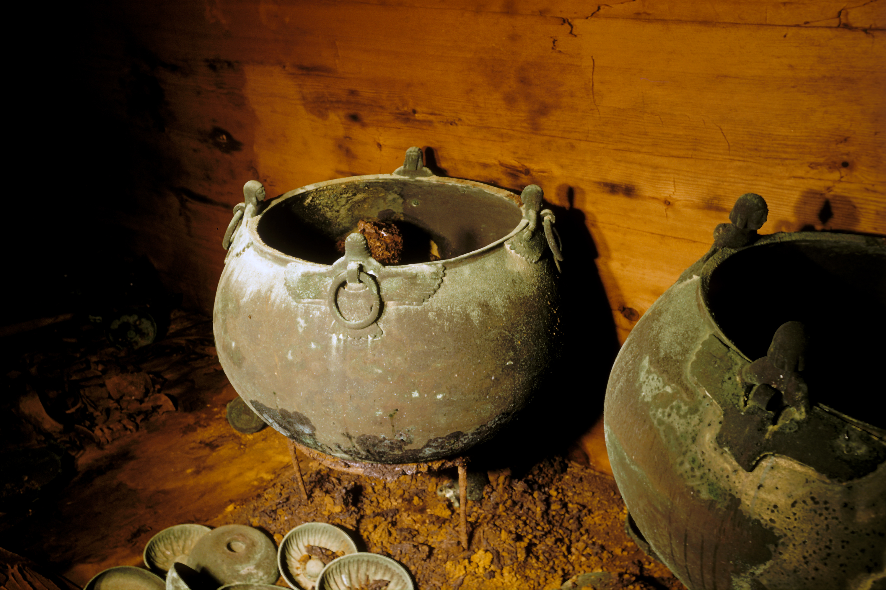
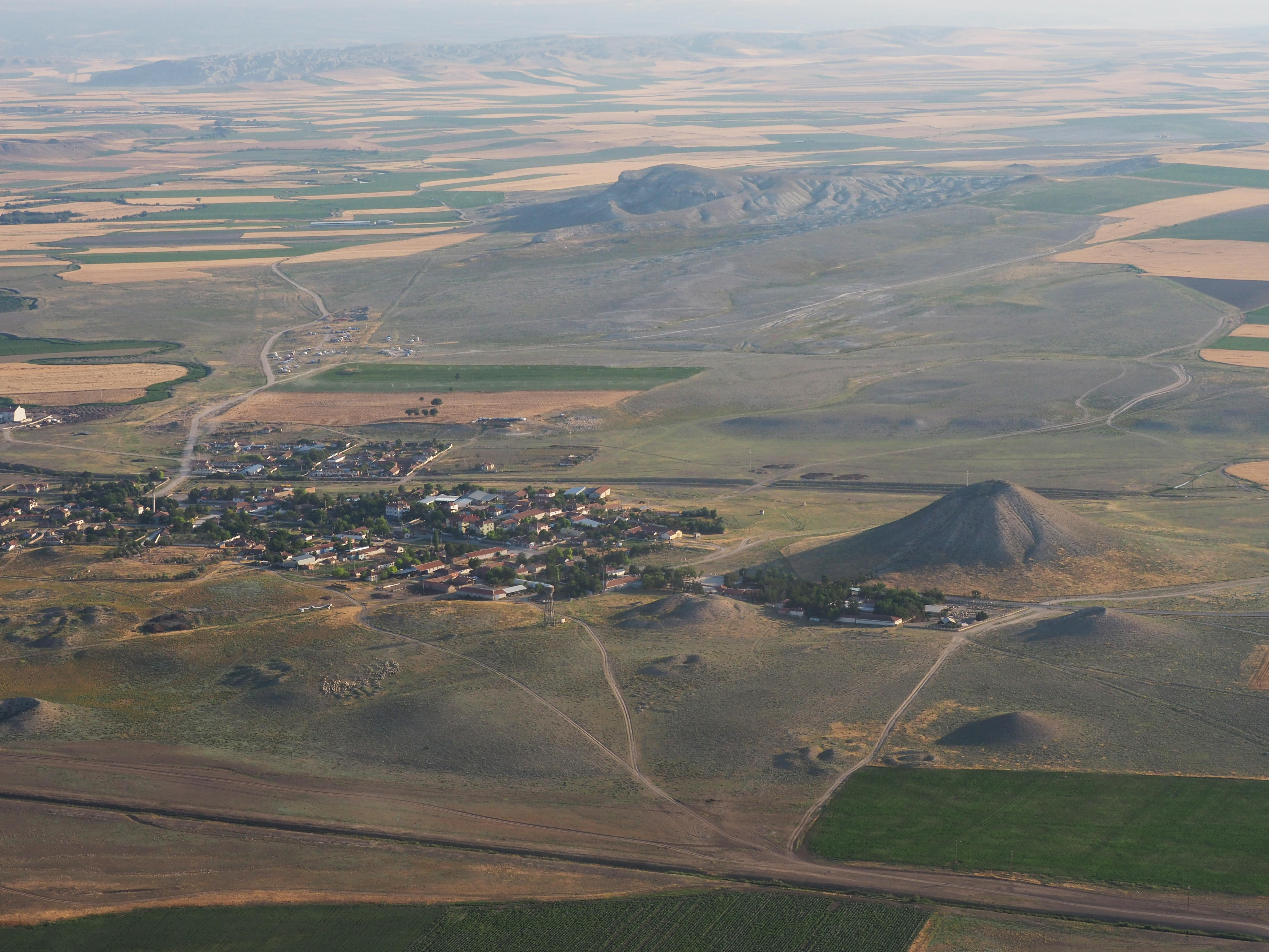
튀르키예 고디온 Gordion
Gordion
Türkiye
Criteria: (iii)
Located in an open rural landscape, the archaeological site of Gordion is a multi-layered ancient settlement, encompassing the remains of the ancient capital of Phrygia, an Iron Age independent kingdom. The key elements of this archaeological site include the Citadel Mound, the Lower Town, the Outer Town and Fortifications, and several burial mounds and tumuli with their surrounding landscape. Archaeological excavations and research have revealed a wealth of remains that document construction techniques, spatial arrangements, defensive structures, and inhumation practices that shed light on Phrygian culture and economy.


탁 트인 농촌 풍경에 위치한 고르디온 고고학 유적은 철기시대 독립 왕국인 고대 수도 프리기아 Phrygia 유적을 아우르는 다층적 고대 정착지다.
이 유적을 구성하는 주요 요소로는 Citadel Mound(도시 성채 정도로 옮길 수 있을 듯), 로어 타운 Lower Town (저지대 마을), 아우터 타운 Outer Town (외곽마을)과 관련 성채, 그리고 주변 경관과 함께 무덤들이 있다.
고고학 발굴과 연구를 통해 건축 기법, 공간 배치, 방어 구조, 매장 방식 등을 파악함으로써 프리기아 문화와 경제를 조명하는 길을 열었다.
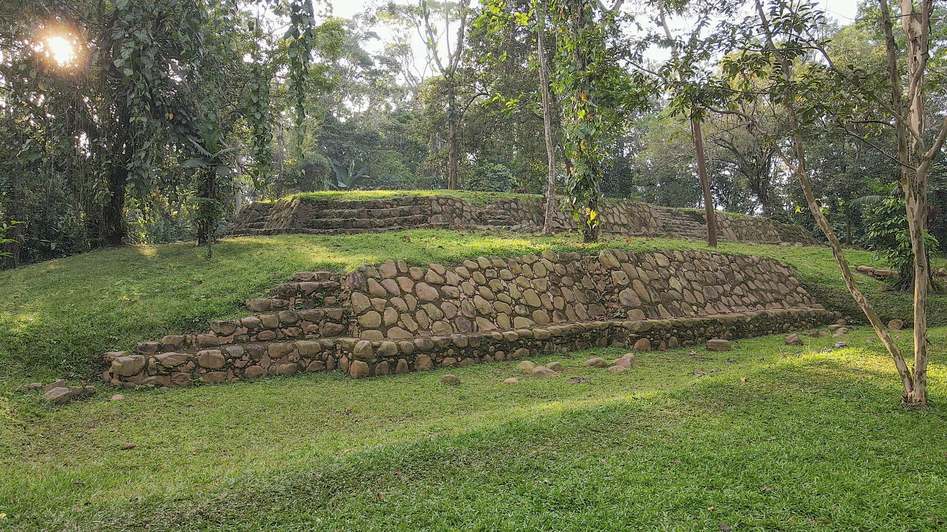
과테말라 국립 고고학공원 Tak’alik Ab’aj
National Archaeological Park Tak’alik Ab’aj
Guatemala
Date of Inscription: 2023
Criteria: (ii)(iii)
Property : 14.88 ha
Dossier: 1663
N14 38 19 W91 43 57
자료 업로딩 안된 상태, 아래 사진만 몇 장 올랐음


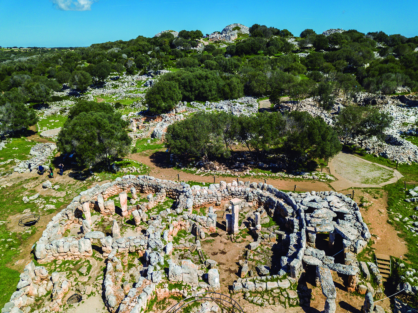
스페인 선사유적 탈라요틱 메노르카 Talayotic Menorca
Prehistoric Sites of Talayotic Menorca
Spain
Criteria: (iii)(iv)
Located on the island of Menorca in the western Mediterranean Sea, these archaeological sites are situated in agro-pastoral landscapes. A testimony to the occupation of the island by prehistoric communities, these sites display a diversity of prehistoric settlements and burial places. The materials, forms and locations of structures dating from the Bronze Age (1600 BCE) to the Late Iron Age (123 BCE) show the evolution of a “cyclopean” architecture built with very large blocks of stone. Astronomical orientations and visual interconnections between prehistoric structures indicate networks with possible cosmological meanings.


지중해 서부 메노르카Menorca 섬에 위치한 이 고고학 유적은 농경 경관에 위치한다. 선사시대 공동체들이 섬을 차지하고 있었음을 보여주는 증거로 다양한 선사시대 정착지와 매장시설을 보여준다.
청동기시대 (1600 BCE) 이래 후기 철기시대 (123 BCE)에 이르는 시기에 만든 건축물들은 재료와 형태, 위치가 매우 큰 돌덩어리로 지은 키클로페아 cyclopean 건축의 진화를 보여준다.
선사시대 구조물 사이에서 발견되는 천문학적 방향들과 시각적 연결들은 아마도 우주론적 의미를 지녔을 네트워크를 암시한다.
체코 Žatec과 경관 Saaz Hops
Žatec and the Landscape of Saaz Hops
Czechia
Criteria: (iii)(iv)(v)
This cultural landscape has been shaped for centuries by the living tradition of cultivating and trading the world’s most renowned hop variety, used in beer production around the globe. The property includes particularly fertile hop fields near the river Ohře that have been farmed continuously for hundreds of years, as well as historic villages and buildings used for processing hops. Urban elements of the property include the medieval centre of Žatec and its 19th to 20th century industrial extension, known as the “Prague Suburb” (Pražské předměstí). Together, these illustrate the evolution of the agro-industrial processes and socio-economic system of growing, drying, certifying and trading hops from the Late Middle Ages to the present.


이 문화 경관은 수세기 동안 전 세계 맥주 생산에서 사용하는 세계에서 가장 유명한 홉 품종을 재배하고 거래하는 살아있는 전통에 따라 형성됐다.
이곳은 오헤 Ohře 강 근처 수백 년 동안 지속적으로 경작된 비옥한 홉 밭과 홉을 가공하는 데 사용한 역사 마을과 건물들을 포함한다.
도시 요소로는 중세 Žatec 중심부와 19세기에서 20세기에 걸쳐 산업이 확장된 프라하 교외(Pražské předměsti)가 있다.
이들은 중세 후기부터 현재에 이르기까지 재배, 건조, 인증, 거래의 농공업화 과정과 사회경제 시스템의 진화를 함께 보여준다.
기타 뉴스 형태로 전달된 세계유산 두 건은 아래와 같다. 이 두 건은 세계유산 등재와 더불어 위험에 처한 유산으로 등재됐다. 둘 다 긴급절차라는 비상수단을 썼다.
레바논 트리폴리 라치드 카라메 국제박람회장
The Rachid Karameh International Fair of Tripoli (Lebanon)
Located in northern Lebanon, the Rachid Karameh International Fair of Tripoli was designed in 1962 by the Brazilian architect Oscar Niemeyer on a 70-hectare site located between the historic centre of Tripoli and the Al Mina port. The main building of the fair consists of a huge covered hall in the shape of a boomerang of 750 metres by 70 metres, a flexible space for countries to install exhibitions.
레바논 북부에 위치한 트리폴리 라치드 카라메 국제박람회장은 1962년 브라질 건축가 오스카 니마이어가 트리폴리 역사 중심지와 알미나 항구 사이에 위치한 70헥타르 부지에 설계했다. 박람회 메인 건물은 가로 750m, 세로 70m 부메랑 모양 거대한 덮개 홀로 구성된다.
The fair was the flagship project of Lebanon's modernization policy in the 1960s. The close collaboration between Oscar Niemeyer, the architect of the project, and Lebanese engineers gave rise to a remarkable example of exchange between different continents. In terms of scale and wealth of formal expression, it is one of the major representative works of 20th century modern architecture in the Arab Near East.
이 박람회는 1960년대 레바논 현대화 정책의 대표적인 프로젝트다. 그 설계자인 오스카 니마이어(Oscar Niemeyer)와 레바논 엔지니어들 간 긴밀한 협력은 서로 다른 대륙 간 교류에 대한 주목할 만한 사례를 낳았다. 형식적 표현의 규모와 풍부함 측면에서 볼 때 이는 아랍 근동 지역 20세기 현대 건축의 주요 대표작 중 하나다.
The World Heritage Committee used an emergency procedure to inscribe the site, due to its alarming state of conservation, the lack of financial resources for its maintenance, and the latent risk of development proposals that could affect the integrity of the complex.
세계유산위원회는 보존 상태가 심상치 않고, 유지관리를 위한 재원이 부족하며, 단지의 완전성에 영향을 미칠 수 있는 개발 제안의 잠재적 위험이 존재하기 때문에 긴급 절차를 이용해 유적을 등재했다.
The site was therefore inscribed on the List of World Heritage in Danger, which opens access to enhanced international assistance both technical and financial.
따라서 이 유산은 위험에 처한 세계유산 목록에 등재되어 기술적, 재정적 지원을 강화할 수 있게 되었다.
고대 사바 왕국의 랜드마크, 마리브(예멘)
Landmarks of Ancient Kingdom of Saba, Marib (Yemen)
The Landmarks of the Ancient Kingdom of Saba, Marib, is a serial property comprising seven archaeological sites that bear witness to the rich Kingdom of Saba and its architectural, aesthetic and technological achievements from the 1st millennium BCE to the arrival of Islam around 630 CE.
고대 사바Saba 왕국 랜드마크인 마리브 Marib 는 기원전 1천년부터 기원후 630년경 이슬람이 도래할 때까지의 풍부한 사바 왕국과 건축적, 미학적, 기술적 업적을 증언하는 7개 고고학 유적으로 구성된 연속 유산이다.
They bear witness to the complex centralized administration of the Kingdom when it controlled much of the incense route across the Arabian Peninsula, playing a key role in the wider network of cultural exchange fostered by trade with the Mediterranean and East Africa.
이들 유산은 아라비아 반도를 가로지르는 많은 향로를 통제한 이 왕국의 복잡한 중앙집권적 행정을 증언하며, 지중해와 동아프리카와의 무역으로 발달한 더 넓은 문화 교류 네트워크에 핵심적인 역할을 했다.
Located in a semi-arid landscape of valleys, mountains and deserts, the property encompasses the remains of large urban settlements with monumental temples, ramparts and other buildings. The irrigation system of ancient Ma'rib reflects technological prowess in hydrological engineering and agriculture on a scale unparalleled in ancient South Arabia, resulting in the creation of the largest ancient man-made oasis.
계곡, 산, 사막의 반건조한 풍경에 위치한 이 부동산 유산은 기념비적인 사원, 성벽 및 기타 건물들이 있는 대규모 도시 정착지 유적을 아우른다. 고대 말리브의 관개 시스템은 고대 남아라비아에서 유례가 없는 규모로 수문공학 및 농업 기술력을 반영하며, 이 덕분에 가장 큰 고대 인간이 만든 오아시스가 탄생했다.
The World Heritage Committee used an emergency procedure to inscribe this site on the List of World Heritage in Danger, due to threats of destruction from the ongoing conflict.
세계유산위원회는 계속되는 분쟁으로 인한 파괴의 위협으로 인해 이 지역을 위험에 처한 세계유산 목록에 등재하기 위해 긴급 절차를 사용했다.
The List of World Heritage in Danger provides access to enhanced international assistance, both technical and financial, and helps mobilize the entire international community for the protection of sites.
위험에 처한 세계유산 목록은 기술적, 재정적으로 강화된 국제적 지원을 받을 수 있도록 하며, 유적 보호를 위해 국제사회 전체를 동원할 수 있도록 돕는다.
'NEWS & THESIS' 카테고리의 다른 글
| 가야고분군의 세계유산 동기동창들(3) (0) | 2023.09.19 |
|---|---|
| 중국고고박물관中国考古博物馆 개관 (0) | 2023.09.19 |
| 러시아와 전쟁통 우크라이나 유산, 위험에 처한 세계문화유산 목록에 올라 (0) | 2023.09.18 |
| 세계유산 등재된 팔레스타인 요르단 강변 고대 예리코Jericho 유적 (0) | 2023.09.18 |
| 가야고분군의 세계유산 동기동창들(1) (2) | 2023.09.18 |


댓글